

For the first time, we can measure the human footprint on Antarctica
- Written by: Shaun Brooks, PhD Candidate, University of Tasmania
Most people picture Antarctica as a frozen continent of wilderness, but people have been living – and building – there for decades. Now, for the first time, we can reveal the human footprint across the entire continent.
Our research, published today in the journal Nature Sustainability, found that while buildings and disturbance cover a small portion of the whole continent, it has an outsized impact on Antartica’s ecosystem.
Read more: Explainer: what any country can and can't do in Antarctica, in the name of science
Our data show 76% of buildings in Antarctica are within just 0.06% of the continent: the ice-free areas within 5km of the coast. This coastal fringe is particularly important as it provides access to the Southern Ocean for penguins and seals, as well as providing a typically wetter climate suitable for plant life.
A hard question to answer
How much land we collectively impact with infrastructure in Antarctica has been a question raised for decades, but until now has been difficult to answer. The good news is it’s a relatively small area. The bigger issue is where it is. Together with our colleagues Dana Bergstrom and John van den Hoff, we have made the first measurement of the “footprint” of buildings and disturbed ice-free ground across Antarctica.
This equates to more than 390,000 square metres of buildings on the icy continent, with a further 5,200,000m² of disturbance just to ice-free land. To put it another way, there is more than 1,100m² of disturbed ground per person in Antarctica at its most populated in summer. This is caused primarily by the 30 nations with infrastructure in Antarctica, along with some presence from the tourism industry.
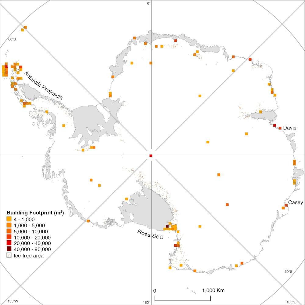 Figure Building footprint density.
Nature Sustainability
Figure Building footprint density.
Nature Sustainability
It has taken until now to find the extent of our impact because of difficulty in gathering the data. Because so many countries are active in Antarctica, getting them to provide data on their infrastructure has been very slow. As two-thirds of research stations were built before the adoption of the Protocol on Environmental Protection to the Antarctic Treaty, they did not require environmental impact assessments or monitoring, so it is quite likely many of the operators do not have accessible data on their footprints. In addition, due to the inherent difficulty in accessing Antarctica, and the vast distances between each station, it is not possible to conduct field measurements on a continental scale.
To address these problems, our team took an established approach to measuring a single station’s footprint, and applied it to 158 locations across the continent using satellite imagery. The majority of images used were freely sourced from Google Earth, enabled by continually increasing improvements in resolution and coverage.
This process took hours of painstaking “digitisation” – where the spatially accurate images of buildings and disturbed ground were manually mapped within a computer program to create the data.
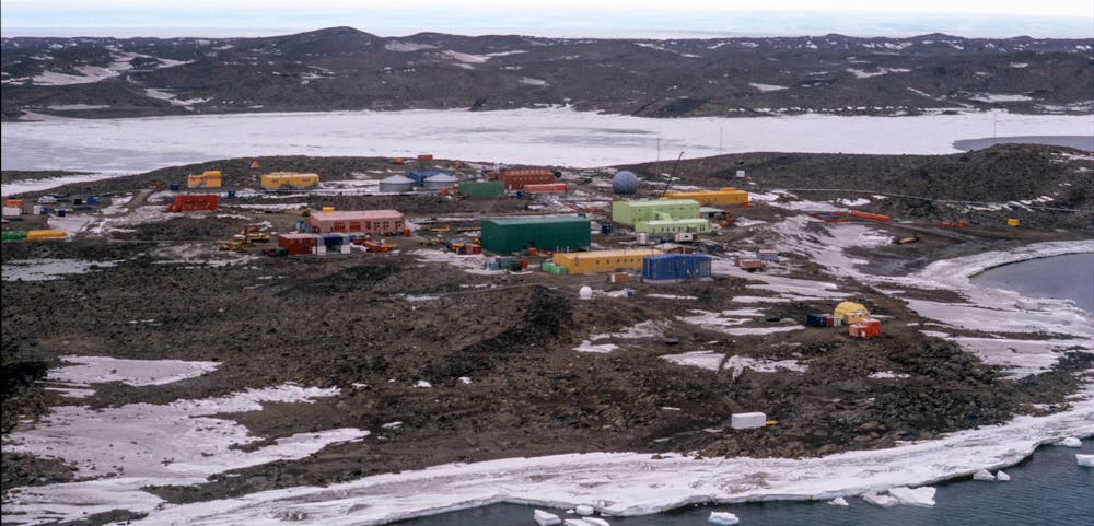 Davis Station, one of Australia’s three permanent research outposts in Antartica. Researchers used Google Earth images to map the footprint of human infrastructure across the continent.
Shaun Brooks, Author provided
Davis Station, one of Australia’s three permanent research outposts in Antartica. Researchers used Google Earth images to map the footprint of human infrastructure across the continent.
Shaun Brooks, Author provided
Interestingly, one of the most difficult sites was the United States’ Amundsen-Scott Station. As this station is located on the geographic South Pole, very few satellites pass overhead. This problem was eventually solved by trawling through thousands of aerial images produced by NASA’s Operation IceBridge, where we found their aircraft had flown over the station in 2010. After capturing these data, we then compared our measurements against existing known building sizes and found our accuracy was within 2%.
Unlike buildings, we didn’t have measurements to compare for disturbed ground such as roadways, airstrips, quarries and the like. We believe we have produced a significant underestimate, due to factors including snow cover and insufficient image resolution obscuring smaller features such as walking tracks.
Read more: Antarctic seas host a surprising mix of lifeforms – and now we can map them
Location, location, location
After mapping the footprint of buildings and ground disturbance our data has yielded some interesting results. For practical reasons, most stations in Antarctica are located within the small ice-free areas spread across the continent, particularly around the coast. In addition to being attractive to us, these areas are essential for much of Antarctica’s biodiversity by providing nesting sites for seabirds and penguins, substrate for mosses, lichens, and two vascular plants, and habitat for the continent’s invertebrate species.
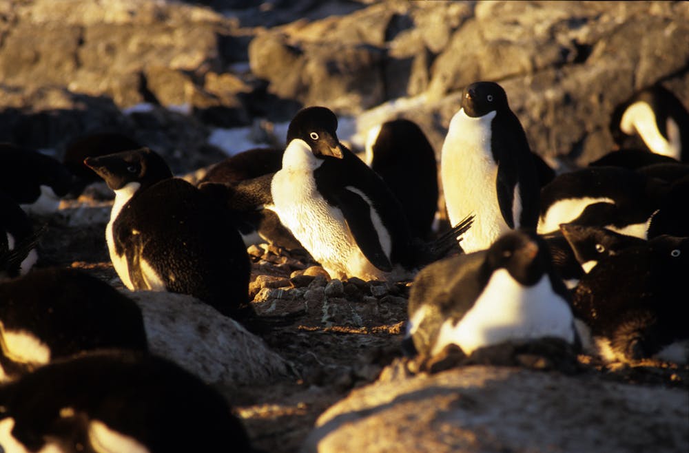 Adelie penguins need ice-free areas to access the ocean.
Shaun Brooks, Author provided
Adelie penguins need ice-free areas to access the ocean.
Shaun Brooks, Author provided
Another interesting finding from these data is what they tell us about wilderness on the continent. Although the current footprint covers a very small fraction of the more than 12 million square kilometres of Antarctica, we found disturbance is present in more than half of all large ice-free areas along the coast. Furthermore, by using the building data we captured, along with existing work by Rupert Summerson, we were also able to estimate the visual footprint, which amounts to an area similar in size to the total ice-free land across the whole continent.
The release of this research is timely, with significant increases in infrastructure proposed for Antarctica. Currently there are new stations proposed by several nations, major rebuilding projects of existing stations underway (including the US’s McMurdo and New Zealand’s Scott Base), and Italy is building a new runway in ice-free areas.
Australia has proposed Antarctica’s first concrete runway, which if built would be the continent’s largest.
Read more: Why Antarctica's sea ice cover is so low (and no, it's not just about climate change)
Until now, decisions on expanding infrastructure have been without the context of how much is already present. We hope informed decisions can now be made by the international community about how much building in Antarctica is appropriate, where it should occur, and how to manage the future of the last great wilderness.
Authors: Shaun Brooks, PhD Candidate, University of Tasmania


