

Here's how a complex low-pressure system sent temperatures plummeting
- Written by: Adam Morgan, Senior Meteorologist, Australian Bureau of Meteorology
New South Wales, Victoria, Tasmania and South Australia are currently affected by a massive complex low pressure system, dropping temperatures and bringing rain, hail, wind and snow.
While complex low pressure systems like this come along every year or so, some Australians may be feeling whiplash after a particularly warm autumn.
Complex lows
Typically, as Victoria and Tasmania head into winter we see cold fronts that move from west to east, generating rain and thunderstorms. This weather system started off like that, but developed into a complex low that will stay with us for the rest of the week.
It’s the kind of weather system you see on average once every year or two. What is a little unusual is to see such a deep pool of cold Antarctic air so early in May. Canberra, for example, is forecast to have a maximum of 9℃ on Friday – which would be its coldest day in the first half of May since 1970.
Read more: Cold weather is a bigger killer than extreme heat – here's why
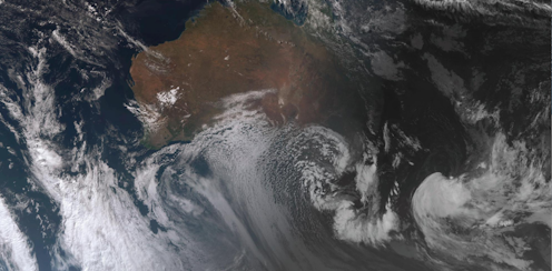
In weather-speak, “complex” describes a weather system with an intricate structure. Starting as a cold front across Victoria and Tasmania, this complex low now has multiple low-pressure centres at the surface, and is interacting with a broad low-pressure system in the upper levels of the atmosphere. These upper and low-level weather systems reinforce each other.
The other factor contributing to the complexity is the warmer waters of the Tasman Sea. The East Australian Current brings warmer waters down the east coast, raising ocean surface temperatures in the Tasman Sea relative to the neighbouring Bass Strait and Southern Ocean. When these low pressure systems develop over the western Tasman Sea, that warm water provides a lot more energy through evaporation.
When all the elements align, with a cold front and its associated cold air mass moving over warm water, beneath an upper-level low in the same place providing reinforcement, a deep and complex low-pressure system can develop.
Difficult to predict
The Bureau of Meteorology usually has several days’ indication that a system like this may form, but development of multiple low-pressure centres at the surface makes it tricky to predict exactly where local impacts will strike.
These small-scale low-pressure centres influence exactly where the heaviest rain or strongest winds will be, as do features of the landscape like mountain ranges.
While we can make broad predictions of what may be on the way, it’s not until we get closer to the event that we can really start to be more specific about rainfall totals, wind speeds, and so on.
The Bureau gets minute-to-minute readings from our Automatic Weather Stations, but we have the ability increase the frequency of some of our measurements (for example, at the moment we have increased the frequency of weather balloon releases at Hobart airport), to get additional information about the atmosphere.
This system will move fairly slowly over the next couple of days, and different elements will impact different parts of Australia.
We’ve got cold air, wind and showers over Victoria and southern New South Wales at the moment, but there are parts of the east coast that are still quite warm today. Tasmania is starting to see windy conditions in Hobart and rain developing, and potentially heavy rain through the east of the state over the next couple of days.
Once the cold air moves further north into NSW we’ll expect snow at lower levels as far north as the Central Tablelands, and then as we move into the weekend the low pressure system will move out into the Tasman Sea.
We’ll then start to see swell increase, as the ocean responds to the weather system. Heavy swell and hazardous surf conditions could push well north along the NSW coast and potentially into southern Queensland by early next week.
Weather warnings
Currently, severe weather warnings for wind have been issued across parts of South Australia, Victoria, New South Wales and Tasmania. Heavy rain warnings and flood watches are in place in Victoria, and flood watches and warnings are current in Tasmania as well.
Other specific warnings provide important information for those on the land - the Bureau has alerted sheep graziers, for example, to the impacts of cold, wet and windy conditions on exposed livestock.
While these warnings are all fairly standard for this kind of weather system, always follow the advice of emergency services. We’re the weather experts, but they’re certainly the experts on preparing for hazardous weather!
Read more: Too wet? Too cold? Too hot? This is how weather affects the trips we make
We’d also advise everyone to keep up with the forecasts and warnings on the Bureau of Meteorology over the next few days.
Authors: Adam Morgan, Senior Meteorologist, Australian Bureau of Meteorology


